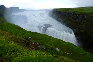
These photos just about sum up Marie's and my 4-day trek through the heart of Iceland. The incredible trail that goes (in either direction) between Landmannalagur to Thorsmork spans diverse and breathtaking scenery, challenges body and mind and leaves tired hikers grateful for the warm, dry hut awaiting them at the end of that day's stage.
There is a wonderful network of huts spaced out along the trail and give a good day's hike between them (12-15 km/7-9.5 mi). Each hut has a different layout and personality, but all are welcoming, clean and manned with a ranger. Bed "slots" and basic kitchen equipment are available for sharing among campers. Earplugs not included...
We chose to go from north to south, and this is the more challenging direction on the first day: 600 vertical meters (about 1900 feet!) in just 12 km/7.3mi. My knees were killing me. At the summit it was blizzarding and we passed a memorial to a hiker killed in a freak June blizzard, on that exact date eight years previous. Sobering.
While it would have been nice to end in Landmannalagur and its hotsprings, we chose to begin our journey there.
This is me before entering the springs. There's a sign warning you about "hikers itch." Marie has clearly ignored it.
Cold to cool to warm to HOT! water in this geothermal hot pot.
Bliss. And my toes before I lost three toenails from the hike.
Hot rivers! How awesome is this?
The first glacier we crossed.
One of my faves of us. First day, clean, not sore and very excited.
Um, Marie? There seems to be steam coming out of this mountain.
And it smells like eggs.
Interminable. Crossing glaciers is like walking on sand.
Marie's stunning photo of the radiant rhyolite hills.
Day two was 13km of largely downhill terrain, and the pounding took a beating on my knees.
The view before arriving at day two's hut, right next to the lake. It's like the Land Before Time!
My knee hurt too much to walk around the lake. I wish I'd done it anyway.
Believe it or not, it was way more gorgeous in person.
Day three was mildly flatter and also longer, 15km.
Day four... while we thoroughly enjoyed our trek, we were soooo ready to be at the hut,
which we had a hard time finding.
Hard not to be in love with the view. This is getting lower in elevation and the greenery and lushness of the ground cover has returned. Thorsmork (Thor's Woods), indeed.
The tongue of M´yrdsaljökull, a large glacier.
I think this is the descent into a ravine-type crevasse... there was a rope involved.
Somehow I have not included photos of the 4 glacial rivers we had to cross. Glacial is the only word to describe them (a) because they are runoff from glaciers and (b) the water must be 32.1 degrees. I've never been in water that cold. The flow of the current is surprising and we had to be careful where we crossed as it is deceptively deep; I almost went in once. By the time I had nearly crossed the water my feet and ankles were literally so cold I could hardly move them and they hurt.
The morning of our 5th day, and clear and sunny. Ejafjallajökull bids us farewell.
We were waiting here for the bus to take us back to Reykjavík. We boarded, and as we were crossing one of the rivers on our way out, the bus began to fill with water. My mind flashed back to the photo album in the hut with all those vehicles swallowed by the river... and then we made it out safely. It's better not to post the photos I took.
A thrilling, lovely, adventurous but safe hike. I thoroughly recommend it!


